Taiwan Atlas report · Health access · November 2026
藥局荒漠:全臺 47 個鄉鎮、28 萬居民境內沒有健保藥局Pharmacy deserts: 47 Taiwan townships, home to 284,000 people, have no local pharmacy
Taiwan's National Health Insurance (健保) has contracts with 10,244 pharmacies. In 47 of Taiwan's 368 townships, none of these pharmacies is located inside the township. This report shows where these townships are, how far their residents must travel to reach a pharmacy, who gives out medicine there today, and how a mobile health team can use this information to decide where to go.
Prepared by an NTU student team for the GBSN Social Logistics Challenge 2026. Meet the team.
一、缺口在哪裡The pharmacy gap is in the mountains and on the islands
The map colours each township by the number of 健保 pharmacies for every 10,000 residents. Townships in red have no pharmacy at all. Move the pointer over a township, or tap it on a phone, to see its figures. Kinmen, Wuqiu and Matsu are far from the main island, so they appear in three small maps below the main map.
Pharmacies for every 10,000 residents, by township
The second map shows how many people live in each square kilometre, with the 47 townships that have no pharmacy outlined in red. Most of these townships are among the most thinly populated places in Taiwan: 35 of the 47 are among the 100 townships with the fewest people per square kilometre. A pharmacy needs enough customers to stay open, so few pharmacies in these places is what we would expect. The gap still matters, because 284,000 people live in these townships and many of them must travel far for medicine. Most of the 12 more crowded exceptions are small islands, such as 七美, 望安 and 南竿.
People per square kilometre, by township, with the townships that have no pharmacy outlined in red
二、缺口的證據Three facts about the gap
A township without a pharmacy can still have good access if a pharmacy sits just across the township border. To find out how serious the gap really is, we checked three questions. How far away is the nearest pharmacy? Are these townships older than the rest of Taiwan? Who gives out medicine in these townships today?
Fact 1. Residents of a typical township drive to the nearest pharmacy, and up to in the mountains. On islands, they need a boat or a plane.
We calculated the drive by car on the real road network, from each township's health station (衛生所) to the nearest 健保 pharmacy. The road is usually one and a half to two times longer than the straight line, and much longer in the mountains: from 達仁 the straight line is 28 km, but the drive is 41 km and takes almost an hour. A resident without a car takes longer still, because buses run rarely on these roads.
Drive time by car to the nearest 健保 pharmacy, for townships that have none
Fact 2. These townships have the same share of older residents as the rest of Taiwan. Terrain explains the gap better than age does.
We expected the oldest townships to have the fewest pharmacies. The data shows something different. In the 47 townships without a pharmacy, of residents are 65 or older. In the rest of Taiwan, the share is . Across all 368 townships, the share of older residents tells you almost nothing about how many pharmacies a township has. What these 47 townships share is their location: most are indigenous townships in the mountains or townships on outlying islands. Some of them are very old, such as 平溪 (37% aged 65+) and 坪林 (33%). Others are young, such as 蘭嶼 (11%). An outreach plan should therefore treat old townships and young townships differently.
Share of residents aged 65+ compared with pharmacies for every 10,000 residents, all 368 townships
Fact 3. In 45 of these townships, doctors at the health station or a clinic hand out the medicine.
of the 47 townships have a health station or a Western-medicine clinic. In these townships, the doctor dispenses the medicine directly (醫師親自調劑). Two townships have neither. Residents of 南竿 use the county hospital, and 烏坵, with fewer than 600 residents, has no 健保 facility at all. Long-term-care providers work in 46 of the 47 townships. Their care workers already visit older residents at home, so they could also help deliver medicine and check on patients after a health visit.
Residents aged 65+ who live in a township with no pharmacy, by county
三、現場長什麼樣子What these areas look like on the map
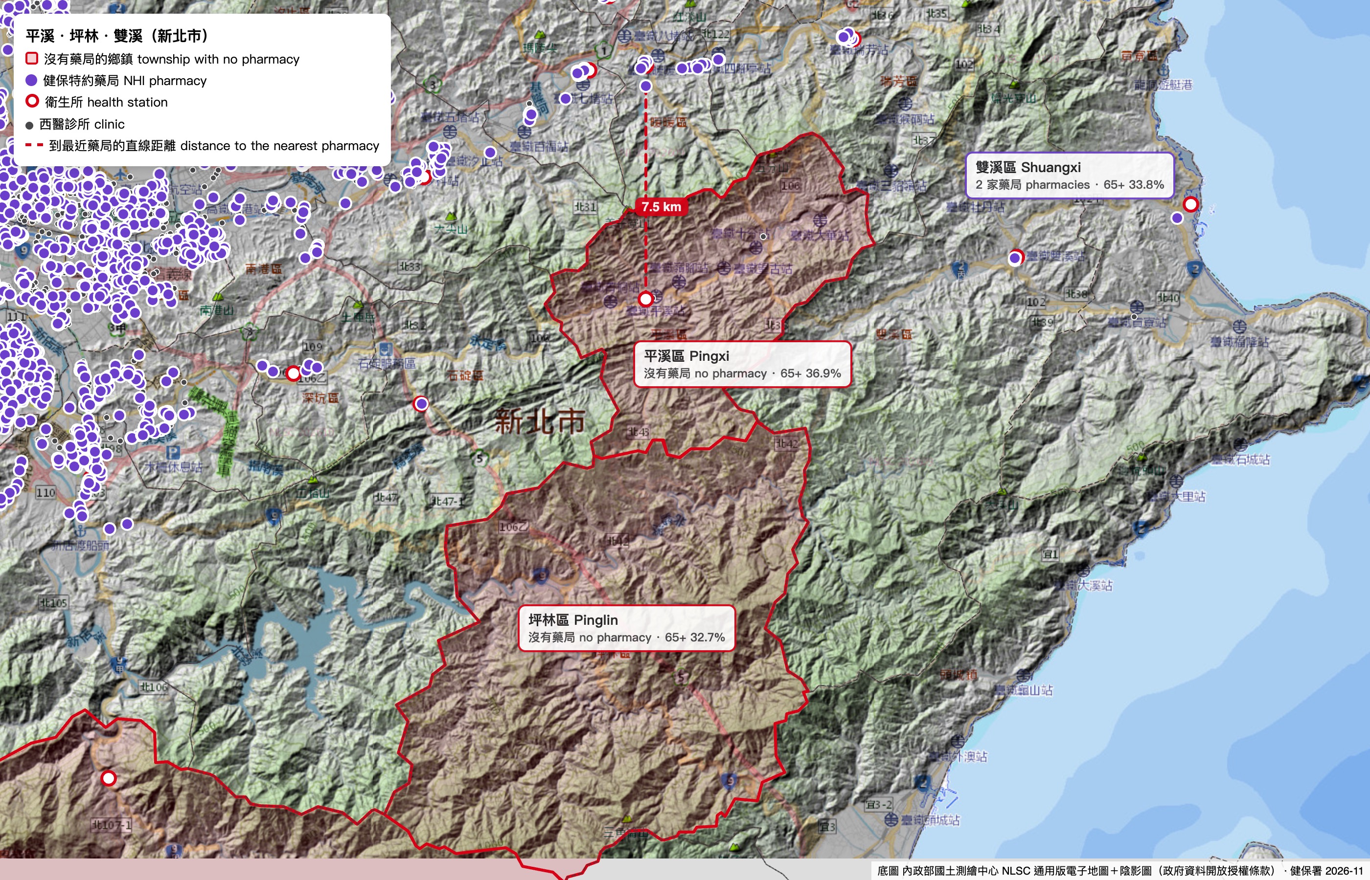
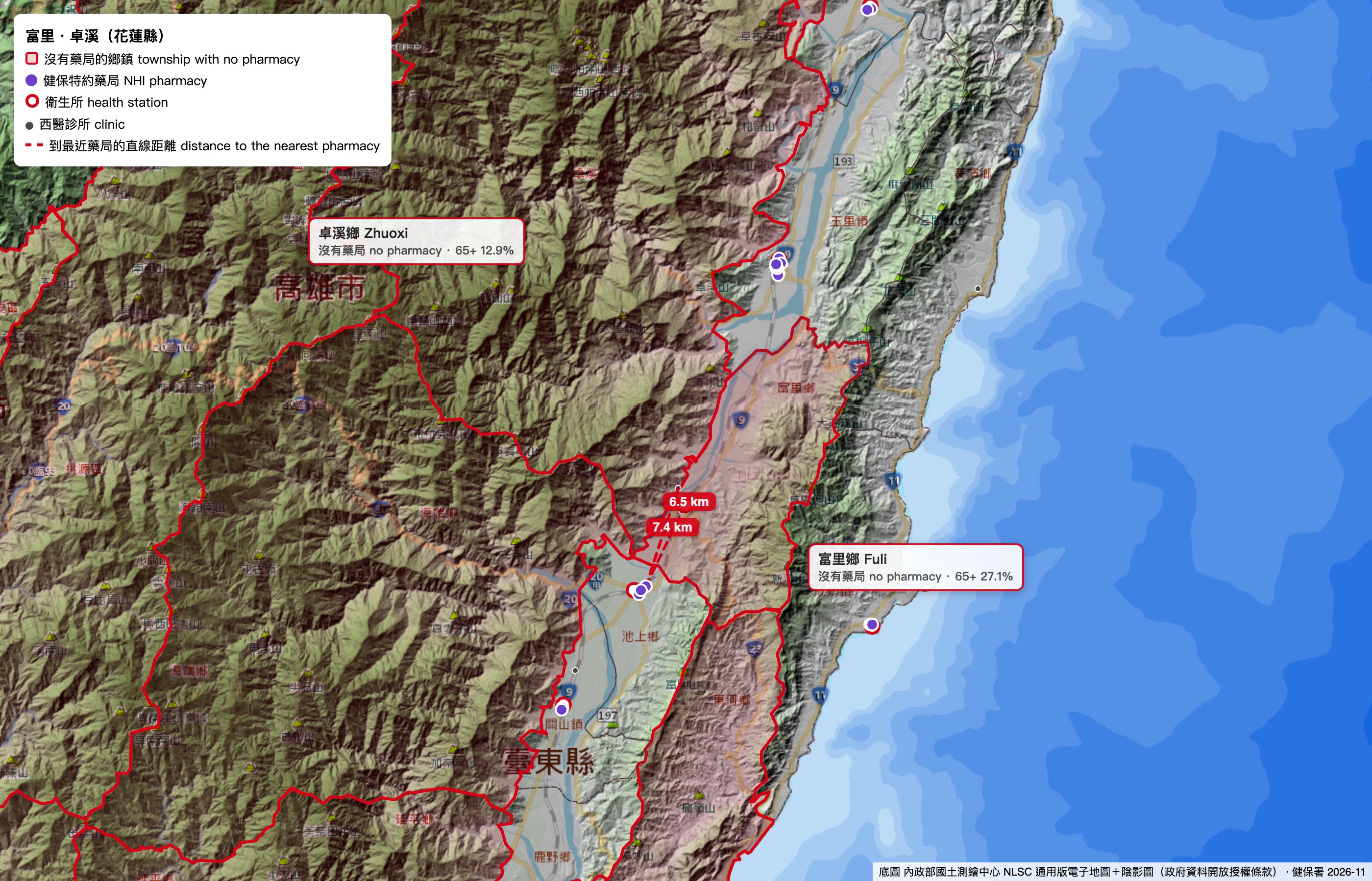
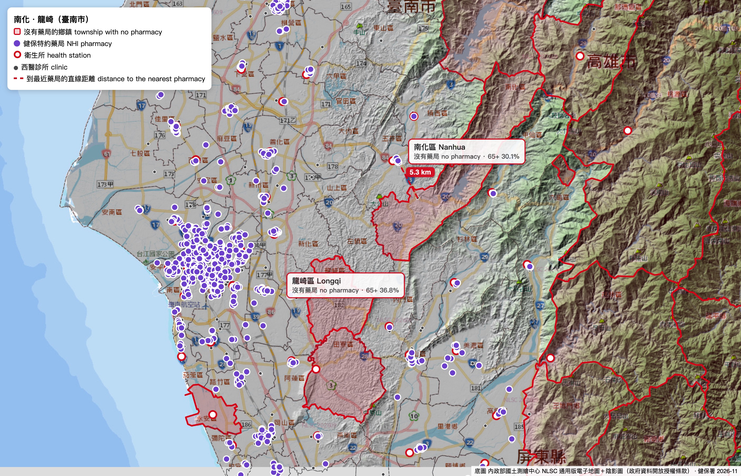
Each map below links to the same area on the interactive Taiwan Atlas map. These four maps show the same health facilities on Taiwan's official national map, with the official terrain shading on top. Red outlines mark townships with no pharmacy, and dashed red lines show the straight-line distance from a township's health station to its nearest pharmacy. Purple dots are 健保 pharmacies, red rings are health stations, and grey dots are Western-medicine clinics. In every area, the pharmacies sit in the main valley town or harbour town, and the townships in the hills around it have only a health station.
平溪, 坪林 and 雙溪 in New Taipei
富里 and 卓溪 in Hualien
南化 and 龍崎 in Tainan
七美 and 望安 in Penghu
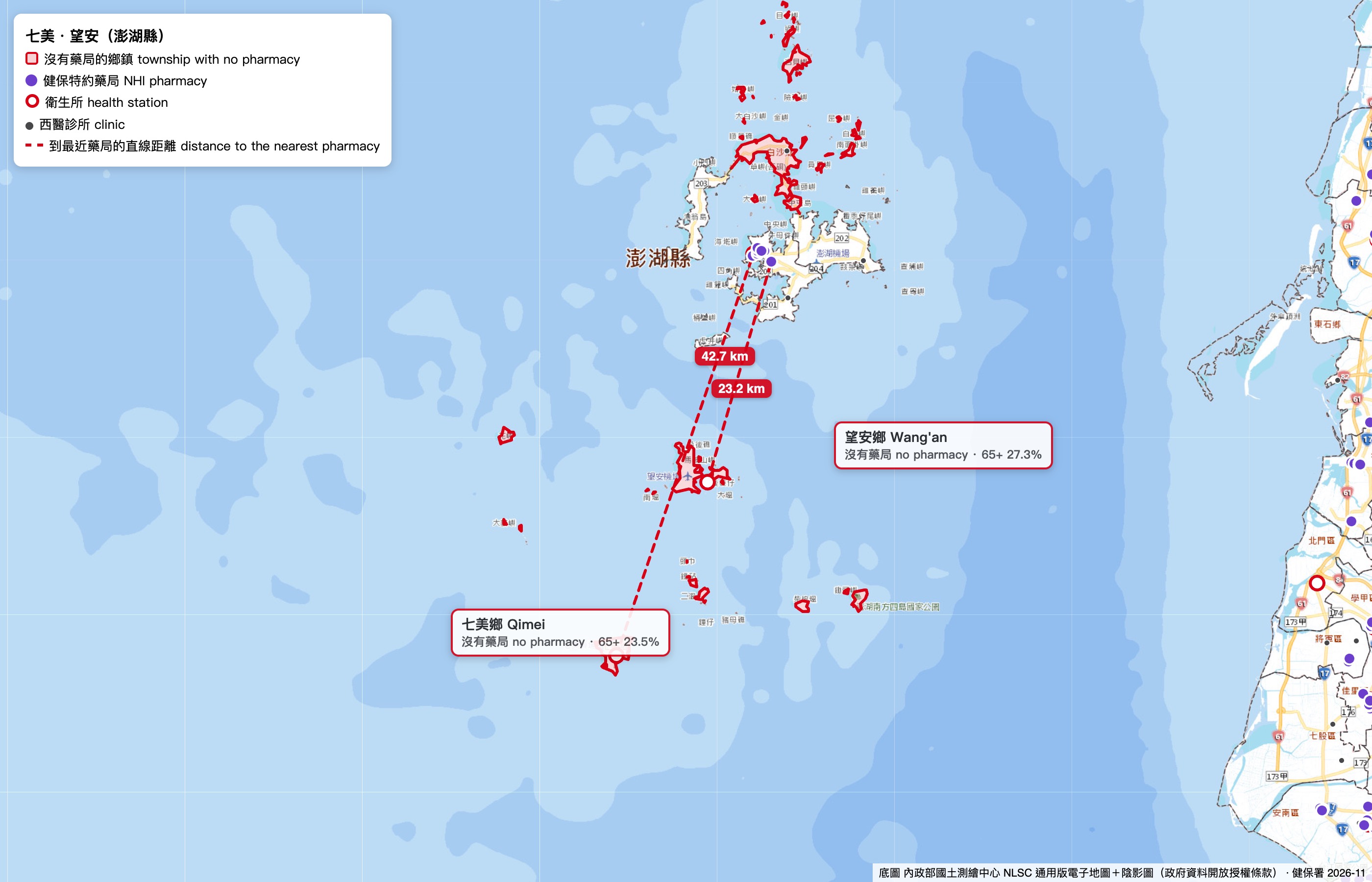
Basemap: 內政部國土測繪中心 (NLSC) national electronic map and terrain shading, 政府資料開放授權條款.
四、先去哪裡Where a health outreach team should go first
The chart below places each township without a pharmacy on two measures. The horizontal axis shows how many residents are 65 or older, which tells a team how many people need care. The vertical axis shows how many minutes the drive to the nearest pharmacy takes, which tells a team how hard it is for those people to get medicine. Islands sit at the top, because their residents need a boat or a plane. Townships in the shaded area have at least 1,000 residents aged 65+ and a pharmacy at least 15 minutes away by car, or sit on an island. A visit to one of these townships reaches the most people who have the hardest time getting medicine.
Residents aged 65+ compared with the distance to the nearest pharmacy
Click a column heading to sort the table. The clinic count includes health stations and general and specialist Western-medicine clinics. It leaves out dental and Chinese-medicine clinics.
五、怎麼用這份資料How a health team can use this report
Doctors, nurses and social workers already run free health check-ups in remote townships. They measure blood pressure and blood oxygen, give out pain-relief patches and teach residents how to look after their health. These teams also face logistics questions: where to go, what to bring and what happens after they leave. This report helps answer each of these questions.
Choose the township
The ranking in section four shows which townships have many older residents and the longest distance to medicine.
Pack for the township
A township where 30% of residents are 65+ needs more blood-pressure cuffs and medicine counselling. A young indigenous township needs more first aid and health education for students.
Combine nearby townships
A team can visit neighbouring townships on one trip, such as Fuli and Zhuoxi, or Nanhua, Longqi and Zuozhen. A regular return date lets the team re-check anyone with a high reading.
Follow up after the visit
Each person with a high reading receives a referral card that names the nearest clinic and pharmacy. The health station or a care worker then checks that the person saw a doctor.
How to measure the result
What the team does
- The team plans two trips with the ranking.
- The team uses a standard kit and referral card.
- The health station or a care worker calls each referred person.
What the team produces
- The number of residents screened on each trip.
- The number of referrals given out.
The team counts both on every trip.
What changes for residents
- More referred residents see a doctor.
- More chronic patients have enough medicine at home.
The share of referred residents who see a doctor within 30 days, and the share of chronic patients with at least 7 days of medicine at the follow-up.
The long-term effect
- Fewer residents in the target townships have uncontrolled blood pressure.
The share of re-checked residents whose blood pressure is below 140/90 at the next visit.
六、訪談題綱Questions to ask a health outreach team
These questions help a researcher learn how an outreach team works and whether this report matches what the team sees in the field. Ask for permission before recording or quoting anyone, and collect counts instead of personal details.
1. How the team plans a trip
- How does the team choose which township to visit, and who makes the decision?The answer may be an invitation, a church or tribal contact, a past visit, or a known need.
- How often does the team return to the same township?
- How many doctors, nurses, social workers and students join a trip?
2. What the team brings
- What does the team pack, and which supplies run out first?
- How does the team transport the equipment, what does one trip cost, and who pays for it?
- What would the team like to bring that it cannot bring today?
3. What the team finds
- How many people come to a typical session, and who are they?
- About what share of the people screened have high blood pressure or low blood oxygen?
- How often does the team meet people who have run out of their regular medicine?Ask how these people normally refill a chronic prescription (慢箋) and how far they travel to do it.
4. What happens after the visit
- What does the team do when someone has a dangerous reading?
- Does the team find out whether that person saw a doctor afterwards?
- Does the team keep records on paper or on a computer, and who can see them?
5. What the team thinks of this report
- Does the ranking for the team's own region match what the team sees in the field?
- Which township would the team add to the list or remove from it, and why?
- Would a list like this change where the team goes next time?
6. Working together
- Can a researcher join the team's next trip?
- Can the team share anonymous counts of people screened, referrals and follow-ups?
- Which person at the local health station should a researcher contact?
七、這份資料無法告訴你的事What this data cannot tell you
- Residents of these townships can still get medicine. Where no pharmacist works, the law allows doctors at health stations and clinics to dispense medicine (藥事法第102條). The real gaps are pharmacist advice and easy prescription refills. Interviews with residents and health workers should confirm how large these gaps are.
- The roster changes every day. This report uses the 健保署 roster of 7 November 2026. Facilities that opened or closed after that date are missing from it, and a township may have gained or lost a pharmacy since.
- Visiting care is missing from the counts. Mobile clinics, IDS specialist visits, home medical care and pharmacist home visits serve many of these townships without having an address there, so the counts show only facilities with a fixed address.
- The address decides the township. Each facility is counted in the township of the address the 健保署 publishes. A pharmacy just across a township border may serve residents of the next township, and the distance figures account for that, while the counts do not.
- Some programmes already serve these townships. 健保's IDS programme for mountain and island areas sends specialist doctors to many of them. Any new effort should explain how it adds to this programme.
- Drive times assume a car on a clear road. They follow the OpenStreetMap road network at typical speeds, with no traffic, no landslides and no typhoon closures, so real trips can take longer. Many older residents do not drive, and a bus trip takes much longer. Each drive starts at the township's health station, or at a clinic or a care provider where the township has no health station on record.
- Some townships have no distance figure. The report gives no distances for townships in Yilan, Nantou, Chiayi City and Lienchiang. Six of the 47 townships without a pharmacy are in these counties. All four counties are included in every count, and the pharmacy counts are complete for every township.
- Population figures follow household registration. Many people registered in mountain townships actually live in cities, and some people who live in these townships are registered elsewhere. The age figures are from August 2025.
- The report counts 健保 pharmacies only. Drugstores without a 健保 contract cannot fill a 健保 prescription, so the report leaves them out.
報告團隊The team
An NTU student team prepared this report for the GBSN Social Logistics Challenge 2026.
- Hoang Phuong Doan, School of Political Science and Economics, National Taiwan University (data and technology)
- Li-Chung (Richard) Cheng, Global MBA, College of Management, National Taiwan University
- Po-Yu Chiang (江柏諭), Department of Accounting, National Taiwan University
- Dennis, Global MBA, College of Management, National Taiwan University
The team used an AI assistant (Claude) to help gather the data, draw the charts and draft the text. The team is responsible for the content and checks every figure against the sources listed below.
資料來源Sources
- 衛生福利部中央健康保險署: 健保 contracted pharmacies, clinics, medical centres, regional hospitals and district hospitals (data.gov.tw 39280–39284), November 2026.
- 內政部戶政司: township population at the end of 2025, and village population by single year of age, August 2025.
- 衛生福利部: 長照ABC據點, the register of long-term-care service points (data.gov.tw 88270).
- 內政部: township boundaries (data.gov.tw 7441).
- 內政部國土測繪中心 (NLSC): national electronic map (通用版電子地圖) and terrain shading (陰影圖).
- Facility locations: Taiwan Atlas (map.tecxmate.com).
- Road network for drive times: © OpenStreetMap contributors (ODbL), November 2026.
- All government data is used under 政府資料開放授權條款第1版.